
The older you get, the stronger the wind gets -and it’s always in your face. -Picasso
Brainerd, MN to Little Falls, MN – 36.2 Miles
After two longer mileage days in a row we were looking forward to only doing around 35 miles today. I told Mike, “It’s going to be an easy day!” I planned to catch up on the blog, do some laundry and other things that needed doing with all the extra time we were going to have. Mike thought he might actually be able to make a tee time for the afternoon. Famous last words.
The mornings have been chilly and today was no different except we had the added ingredient …wind… It was supposed to be about 10 miles an hour, which isn’t a big deal….except it was much stronger than 10 miles an hour. They say that opposites attract and that was our situation today. We were going to spend nearly all of the 35 miles riding due South. The wind was going to spend nearly all day being opposite by blowing non-stop directly from the South. Yep…the dreaded headwind. Mike guesses that it was blowing closer to 25 miles an hour. It was a brutal day and I’m feeling lucky we only had to deal with it for 25 of our 35 miles.
As we rode away from the motel, we needed to navigate a busier street until I was able to reconnect us to the Paul Bunyan Trail. We had about 10 more miles to go before the Paul Bunyan would be in the rear-view mirror. The first couple of miles were through suburbs on recreational bike paths, which were in great shape. After a few twists and turns, where I was wondering if we were still on the right path, we found ourselves heading toward what looked like a deserted dead end cul-de-sac with fencing at the end.
Luckily I remembered this spot and Mike probably thought I was crazy as I headed straight for the fence. There is a cut through the fence that is hard to see until you’re right there. We squeezed ourselves through the cut and continued a short distance to get our first glimpse of the Mississippi since we left Bemidji. The bike path crosses the river in a loop-de-loop sort of way using a busy highway bridge.
 First you go under the bridge on the side you’re on and circle around up to a bike/pedestrian path on the bridge.

Mike managed to get a picture of me today!

Getting ready to go over the bridge.

We’re back on track with the Mississippi today.
At the other end of the bridge, you loop down and go under the bridge again to continue on the trail.
 The trail continued for a few miles through woods with occasional glimpses of the river through the trees.

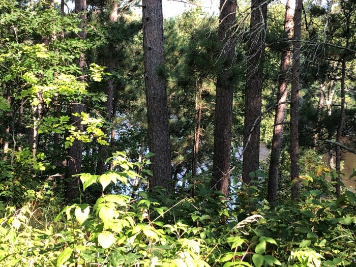
I liked this last part of the trail because it wasn’t built on an old railroad line, instead it loops and curves and goes up and down until the riders pop out at Crow Wing State Park. We enjoyed our ride through there because it’s scenic and because we had some protection from the wind.
At the point the trail connects to the entrance road to the park, it is time to turn left and ride out to the highway to continue on the MRT. Three years ago, Jane refused to believe that there wasn’t some sign officially marking the end of the trail that we could get a picture by. Jane and I turned right instead of left, passed the ranger station and arrived at a parking area with outhouses about 1/2 mile away. Disappointed that there wasn’t anything to take our picture in front of to celebrate – we decided to create our own celebration picture by standing on a stump outside of the outhouses. Of course I had to make Mike go there this time to continue the tradition of marking the end of the Paul Bunyan Trail ! He was nice enough to play along.

This is the exact spot where Jane and I posed 3 years ago.
 As we left Crow Wing State Park and reached the highway – blammo!- we turned right into headwind hell. All we could do was put our heads down and pedal. We were fighting hard just to go 10-11 miles per hour. It was almost like being on a treadmill. The road we were on was mostly flat and at times slightly more downhill than flat and we barely ever went any faster than 12 miles an hour. We were riding along a divided highway and would be on this road for most of the day.
 Mike said that without the wind we would have probably been cruising along at about 15-16 miles an hour. I still have the stats from when Jane and I rode this segment and she and I had a faster average speed then than Mike and I did today. Jane doesn’t ride as fast as Mike and I can.
I knew that the first gas station we’d see would be about 10 miles down the road from the state park. Knowing I was going to get a break there kept me plugging away.


When we got there, we saw that we had caught up with a couple we’d seen earlier riding out of the state park as we were rolling toward the outhouse parking lot. They were riding bikes fully loaded and I bet Mike that they were doing the MRT self-supported.
We stopped to chat with them and found out they are biking the MRT, but doing it in sections with a 5-year plan. (hmmm, good idea!) They’ve already done some of the more southern sections and picked a Minnesota section for this year’s vacation. After they left, I went inside and bought some junk food and Mike and I sat outside and took a long break. While we were sitting out there we met a local “character” who cracked a couple of jokes. When we couldn’t put it off any longer, we got back on the bikes and went back out to do battle.
For the next ten miles or so we played a little game of leap frog with the other couple. We actually “sped” past them not long after the gas station and we were only riding something like 11 miles an hour at the time. If we stopped for a break, they caught us. It was probably like watching turtles race!
When we finally reached a turn-off that we hoped would change our direction a bit, maybe giving the wind a different side of our bodies to sandblast (it didn’t work), it was at Belle Prairie.  Belle Prairie was established as a township in the 1850’s. A group of nuns was sent to establish a missionary/convent around the same time frame. The log cabin in the picture is a replica (I believe) of one of their first domiciles. There is a park behind the cabin with the stations of the cross and a more modern catholic church across the street, which was also originally established when the nuns arrived.
The day never got any easier. Mike said he was waiting for Dorothy and Toto to go flying by. For the last couple of miles our route passed through a neighborhood and that did give a bit of relief, but the wind never died down all day. We finally rolled into Little Falls after 5+ hours on the road and stopped in a park by the Little Falls dam for our final break.
 When I was here before there’d been an interesting historical display at this little park, but it wasn’t there this time. I was disappointed, because I enjoyed seeing it the last time and thought Mike would like it too.
We were ready for lunch and found the nearest place that was serving food.


Laura was able to meet up with us and we had a fun lunch with some locals asking us about our trip and commiserating about the wind. One guy said he’d had to drive to a job site south of town and even in his truck he was thinking the wind was crazy. After lunch we had 1 mile left to go to get to the hotel. We were really glad to put today in the rearview mirror!
Miles so far: 165.2
…Some people feel the rain. Others just get wet. -Bob Marley
Little Falls, MN to St. Cloud, MN – 44.6 Miles
It rained overnight. The forecast for today was reasonably hopeful as far as avoiding more rain, but the day was forecast to be quite gloomy and there was a chance of scattered showers in the afternoon. Our plan was to ride to St. Cloud today. Based on where the hotel was located, I thought it would be about 45-47 miles.
We got ready to go, adding our rain gear to our riding outfits for the day. We left the hotel parking lot in a light drizzle and were lucky enough that that it didn’t get any worse than that while we were riding. We left the rain gear on anyway for the first couple of hours just because it was so damp.
The “official” route passes through Little Falls and crosses the Mississippi, continuing down the western side for quite awhile. When Jane and I were here the local bike shop owner suggested a variation in the route that we quite enjoyed. Mike wanted to use that alternate route because I was familiar with it. We left Little Falls, following the Eastern bank of the Mississippi for about 10 miles. Either way, we were going to have a headwind again, but not quite as strong, thank goodness!
When the road crossed the Soo Line bike trail, we turned onto the trail for about 1/2 mile.  It wasn’t far down this trail to the old railroad bridge (now bike trail bridge) over the river, next to a dam. I stopped to take a few pictures while Mike kept going because he didn’t like being on it.


Gloomy river this morning.
As I was finishing my crossing, I noticed a crane sitting next to the dam and realized that it had a pontoon boat with an aluminum fishing boat on it’s deck hoisted quite high into the air. I am still wondering what the story was. I’m assuming that both boats had gone over the dam at some point. We took a quick break to take off some of our layers and could see our next turn just ahead -where we would rejoin the official route. For the next 12 miles or so, we just kept our heads down and kept pedaling.
 Neither of us felt that energetic today. We were riding pretty slow, but looking forward to our lunch stop in the town of Rice.
We picked the first place we saw, O’Brien’s Pub and were glad to see it was open since it was a bit early for lunch. When we walked in, we were the only people in there beside the bartender, who was also apparently the cook and waitress too, but in the time it took us to grab a bite to eat, the place got pretty lively. 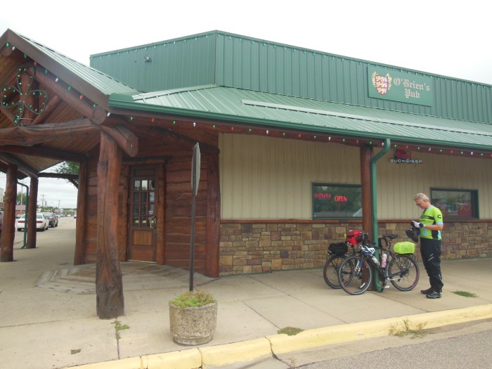 Eventually, we had to face the fact that the bikes weren’t going to ride themselves…so we went back outside to finish our trip to St. Cloud.
Once again, we were just keeping our heads down and keeping the wheels spinning. There were things to look at along the way – neighborhoods, the river, woods, construction -enough to keep it interesting, but with the rain threatening all day I wasn’t pulling out my camera too much. We just wanted to get to the hotel more than anything.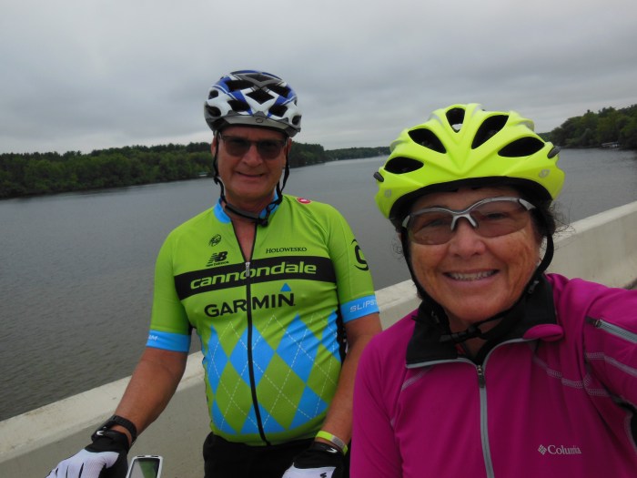
We finally came into the outskirts of St. Cloud. As we passed through a pretty little riverside park, it started to sprinkle again, so Mike wanted to put his rain gear back on. There was a conveniently located pavilion for us to sit under while getting our rain coats on.
 The first time through St. Cloud, Jane and I briefly visited one of the two big gardens there that are practically side by side and thought it was really quite lovely -lots of flowers. Today, Mike and I rode past the other one and it was also really quite nice.
 If Mike hadn’t checked the weather on his phone just a bit before that and seen a thunderstorm heading our way on the radar -we would have stopped for more than a couple of pictures.
We crossed the river again to the campus of St. Cloud State University and took a side ramp at the end of the bridge down to a road that then passed under the bridge we’d just been on. On the other side we segued to a bike path and it started to sprinkle. We tried to ride “horses to the barn” -but somehow our speed just wasn’t up to par. Luckily, it only sprinkled as we worked our way down the path and through a couple of twists and turns (always looking for the MRT sign to confirm we’re going the right way) and a couple of miles later, we popped out onto a side street where I glanced over my shoulder and saw the hotel entrance. YAY! I wasn’t expecting to see it quite that soon because I had been checking my odometer and thought we still had a mile to go. It was a welcome sight for sure! We beat the thunderstorm too!
Miles so far: 209.8
Categories: Brainerd, MN to St. Cloud, MN, MRT Bike Trip 2018 & 2022
This ride is a lot of fun, as I sit on my patio on this windy, chilly, sunny day. Only 52 degrees. It does feel better than the 90’s. Mike’s face looked pretty wet in the last picture. 💦
Yep, we were wet!