
Zion National Park
Mike has wanted to visit the Grand Canyon since he was a kid. I had always envisioned our “someday” trip to the Grand Canyon as a long, wandering sort of road trip that ended when it ended…an old-fashioned load up the car, grab the maps and see where the road leads kind of thing. To do that we had to wait until Mike retired so we wouldn’t be limited by his work schedule. Yet, even a few years into retirement, we still hadn’t seemed to find the right window of time to go out West.
Last winter as we were starting to talk about our upcoming travel plans, Mike told me that the Grand Canyon was a non-negotiable 2022 destination for him. We agreed we’d get to the Grand Canyon in 2022 or bust. It was almost bust! Due to time issues my long imagined, zig-zag trip across the country had to be condensed into a whirlwind ten-day trip where we saw the Grand Canyon plus several other national parks in the same region. We seem to specialize in “whirlwind” and this trip was no exception.
To make the most of the time we had for this trip, we flew to Las Vegas and rented a car. The plan was to drive a very large loop tour starting with Zion National Park and finishing at the Grand Canyon. After picking up the rental car, we drove about two hours or so North of Las Vegas to St. George, Utah. St. George is located about an hour away from Zion National Park.
Other than Las Vegas, we haven’t traveled much in the Western U.S. -so we’re not used to seeing the mountains and views that come with the terrain in Nevada, Utah and Arizona. I think we were a bit starstruck at the overwhelming beauty we saw.
Our first “hint” that we weren’t in Kansas anymore was as we approached St. George.

In St. George, we found a little non-descript Mexican restaurant for dinner. We were there a bit before normal dinner hours, so there weren’t many patrons. We sat at the bar and the only other people in that part of the restaurant were two men. When we asked for our check, the bartender said that one of the men had bought our dinner. We thanked him with grateful smiles and perhaps expressions of bewildered surprise as we’d more or less been minding our business while eating. We then ended up having a short conversation with him before we left. He told us he was a Mormon and said the gentleman with him was one of his brothers. From that point on, I’m still undecided as to whether or not he was pulling some wool over our eyes or really telling us the truth -but he claimed that his father (who would have been around 100 years old, if alive) had had seven wives and that he had something like 70 siblings! He was a bit of a character, had some interesting political views and waxed poetic about a rather large chicken coop he and his brother were building.
Tip #1 for visiting our National Parks: Plan ahead!
The United States has 64 national parks -some more famous than others. In 2021, the national parks combined recorded nearly 300,000,000 visits!
Because we had struggled with finding a window of time for this trip in the first place, I was already behind the 8-ball when I started planning it. Once I figured out what our “points of interest” were, I mapped out a route that would link them together while trying to balance the daily driving distances between them. Then I started looking for accommodations. For both Zion and the Grand Canyon, I would have loved to have stayed in the lodges inside the park -but they were already booked solid when I checked. I think they fill up months in advance.
Planning ahead also includes finding out when and where permits are required and also the timing for when you’re going to be touring. You’ll be happier if you can avoid visiting during the summer months for two big reasons: Smaller crowds and better weather.
In the summer, Zion can have up to 17,000 visitors a day. As you can imagine, there are only so many parking spots inside the park. I found information on-line that said that the parking lot by the visitor center is usually full by 9:00 AM. There is a town called Springdale located about eight miles outside of the main entrance. When the parking lots at Zion fill up, traffic is routed back to Springdale and visitors have to park there to catch a shuttle into the park.
Our plan was to be pulling into a parking spot no later than 8:00 AM -which meant that we had to make a very early start in the morning from St. George.
On the way to the park entrance:


We arrived at the entrance to Zion pretty much as planned and I was excited to whip out my Senior National Park Pass and get waved through with a smile. (Regular entrance to Zion National Park is $35 per vehicle -good for 7 days). The parking lot already looked about half full when we got there. I found the area around the visitor’s center to be quite pretty with information on the various hikes displayed on large panels.

First things first, we had to take a shuttle further into the park for the stop near the trailhead for our hike. They have a well-organized shuttle system in place to take visitors to several drop off points where hikes or various points of interest are because there are limitations as to where a private car can be driven inside the park.
There was a small group of people already in line for the shuttle when it arrived. We were able to walk right on and it wasn’t crowded. I confess to feeling a sense of dread when I looked over at the rather large covered “shuttle stop” awning and saw the dividers in place to make a giant queue line when they need to manage a larger crowd. It looked like it could have been used at an amusement park or for a TSA line at the airport. The Zion website says when the park is crowded, people often wait for up to 30 minutes or more to get on a shuttle and when they do get on it can be standing room only. Mike and I both are extremely uncomfortable in crowds, so were grateful we’d gotten there early. And we were there at the beginning of the slow season for visitors.
It was nice to ride and enjoy the play of the morning sun on the sides of the valley.

We only had a few hours in the schedule to spend at Zion, so I picked the Emerald Pools Trail for us to hike while there. It is one of the easier and more popular trails. There are three “pools” -the upper, middle and lower. If you take the trail through to all three, it is about three miles total and not too much climbing*. (*Mike read this and asked me if we were on the same trail?) Zion has at least 20 trails of varying difficulty to choose from.
It was a little chilly in the shadows of the valley when we got off the shuttle and started our hike, but it was a beautiful day to explore this little part of Zion.

Our trail crossed the road from the shuttle stop and led us to a bridge across the Virgin River.

It took the Virgin River 1 million years to carve the canyon we saw today. The Emerald Pools are the result of water run-off from two side canyons several hundred feet higher up. With gravity’s help, the water finds its own path to the river below. There are a series of waterfalls and pools along the way….when the water is abundant, which it wasn’t when we were there.


For the next hour or so we followed the trail and enjoyed the views.


This is the middle Emerald Pool. There was a serious lack of water at this time of year.

The trail had its ups and downs.

If you look close, you can see the small chain barrier -there’s a cliff on the other side of it. (Which did not have a waterfall going over it!)

This spot had a thin stream of water going over the edge.

The bridge we crossed is below with the river in the distance.

The direction that we took to start this hike brought us to the middle Emerald Pool first.
Where I am standing is usually under water.

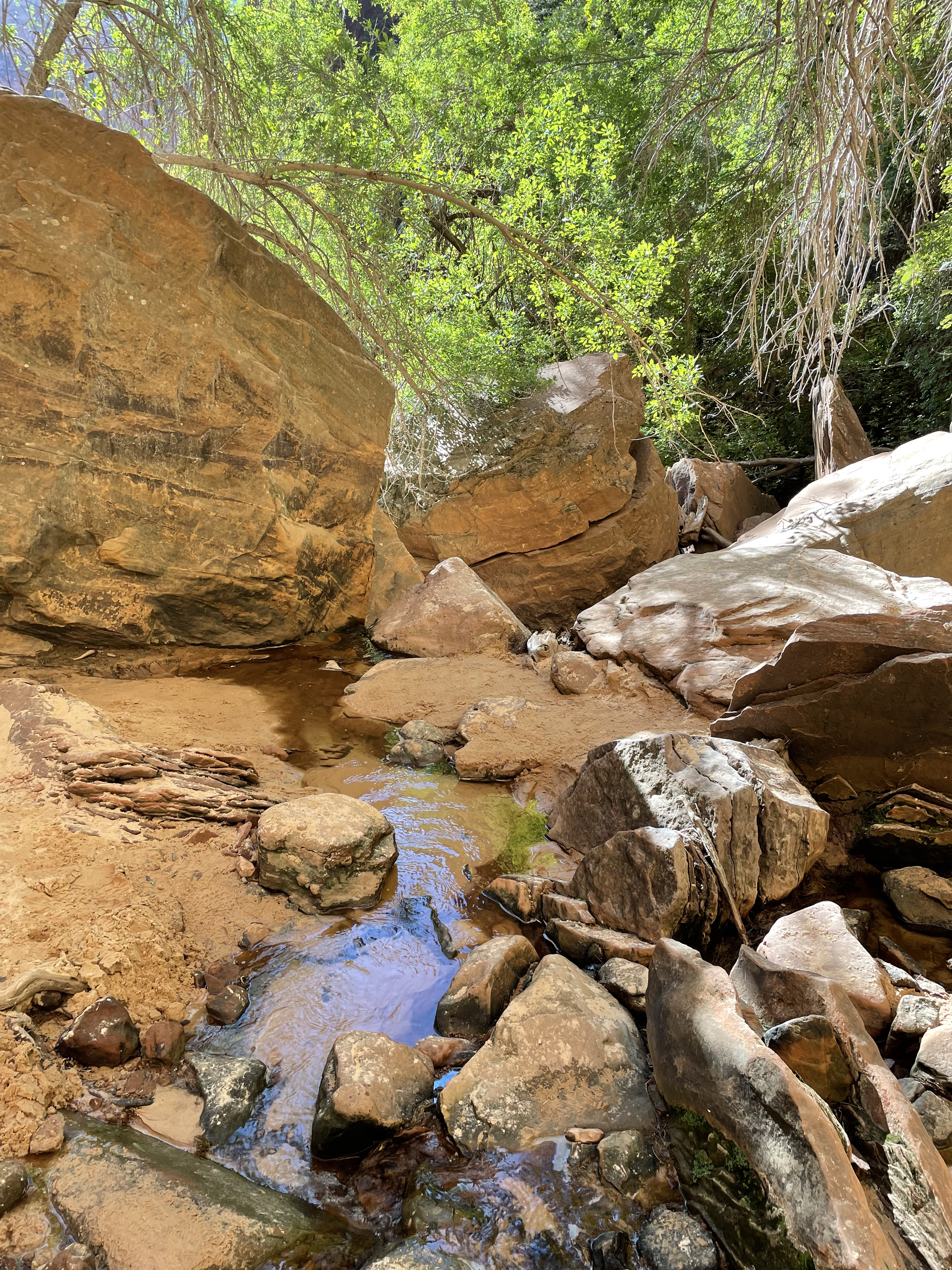
Our next stop was the upper pool area. In the picture you can see where the edge is -not enough water this day to make a waterfall.

This pool is the first stop for the water that drains from the upper canyons on it’s way to the Virgin River. There was a rope hanging down -so I assume that the wall is a sometime route for rock climbers.


A glimpse of part of the trail we followed.

We came to this cool grotto looking spot where three trails crossed. The picture shows how it looked as we approached. The stairs were the second path. The third path is hidden on the right side right around where the bottom of the stairs are. It took forever to get this picture without people in it. At first people kept coming down the stairs and standing at the bottom looking like they were regretting their life choices. We didn’t know that the hidden trail was even there until I was getting ready to hit the button on my picture and someone popped out from the right side looking somewhat bewildered. Whichever way other hikers entered this area from -they all seemed to stand frozen looking at me like “deer in the headlights” or ignoring me as I was obviously (I thought) holding my camera in a way to indicate I was waiting to take a picture. Without them in it !!

We took the trail that led off to the right. We walked a short distance to these steps which ended down toward the lower Emerald Pool.

The lower Emerald Pool loop is mostly paved and we reached the paved part at the bottom of the rocky steps (above) and after crossing a very rickety bridge with a few more steps thrown in. As we arrived at the pavement, it was standing room only as a large group had arrived from the other direction and decided that the path was now their personal group rest area. It was impossible to get a picture from that spot. There was a very thin waterfall falling from above to the pool slightly below us. I took a picture of it from the side and you couldn’t see it at all in the picture. The trail actually passed behind it. I took a picture from that vantage point.

This is what it is supposed to look like with water added.
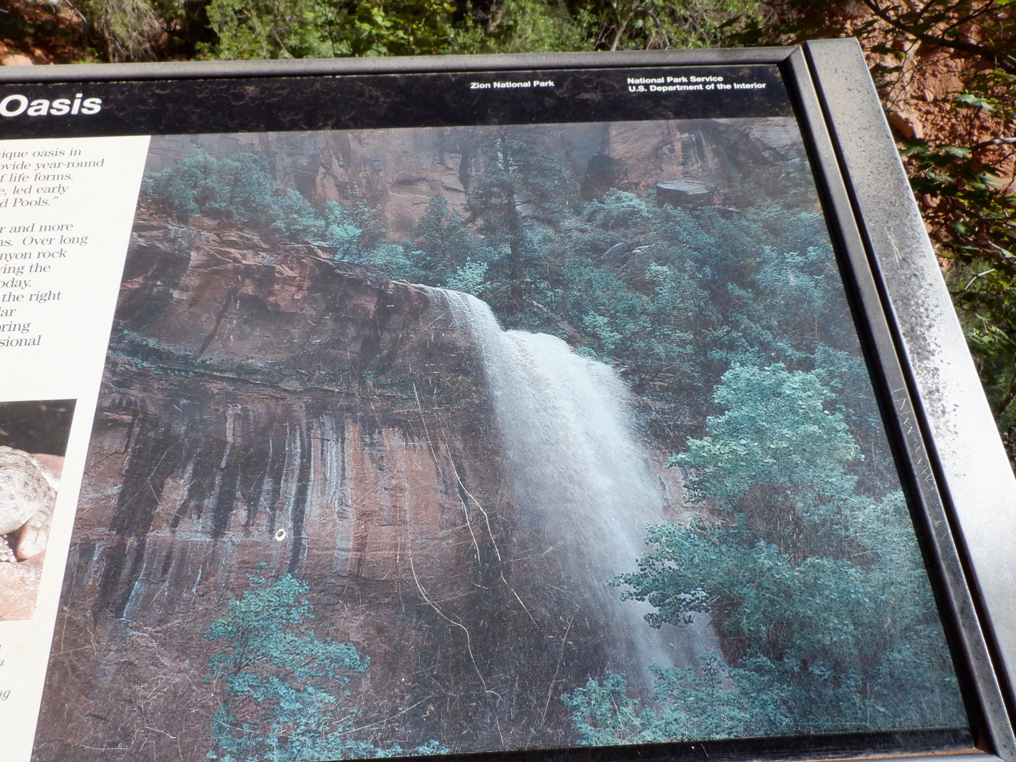
I’m not sure if this is the same location, but you can see the difference the dry season makes.
A few pictures of plants along the way:


By the time we reached the lower pool, we weren’t far from the end of our hike. Before we knew it, we were crossing the bridge again and looking for the correct shuttle stop for our ride back to the visitor’s center.
There was a kissing bandit on the trail!

As we’d followed the road into Zion, I started thinking about what it must have been like for the person who first saw it wild and untouched. Native Americans were in this area as long as 1800 years ago. In 1858, a Mormon man named Nephi Johnson was shown the canyon by a friendly Paiute guide. He was scouting for good locations where Mormons could build settlements. Issac Behunin became the first European-American to settle in the valley. In 1861, he built a log cabin around the location where the Zion Lodge now stands. He named his home Zion. Others soon joined him. Having started our hike near the Zion Lodge, it is hard to imagine farms dotted along the river, especially since the valley is only about 1,000 feet wide at its widest. Thankfully, by the early 1900’s Zion was gaining momentum as a natural wonder that should be protected. Also by then, the settlers who’d tried to make a go of it along the valley retreated to other nearby areas that were better suited for farming. Once Zion was declared a National Park in 1919, it didn’t take long for entrepreneurs to begin creating the infrastructure to make it a tourist destination.
After our hike, we caught the shuttle bus back to the visitor center and our car. Much to the frustration of the drivers circling the parking lot like vultures waiting to swoop in on the carcass of our empty spot; we didn’t leave right away. We faked them out by grabbing a cold drink and a snack out of the car and heading to a nearby picnic table for a small break before we left. When we did head back to our car, it didn’t take but a few seconds to have someone ask us if we were leaving?
Our hotel for the night was in Hatch, Utah, about two hours’ drive from Zion. Other than people staying at the Lodge, who can drive their cars to that parking lot, the only part of Zion where cars are allowed is on Highway 9. Highway 9 enters Zion at the South entrance and exits Zion 14 miles later at the East entrance. Most of those 14 miles are well beyond the small area where most of the visitors congregate.
The first few miles were really pretty as we sort of zig-zagged up higher and higher. Mike pulled over a few times at overlooks through here, but I couldn’t quite get the right angle to show the road’s twists and turns. We were on the road you can see below in the picture not long before I snapped the photo.

I found one on line that might help give a visual. We were surprised to see more than a few bicyclists taking on the challenge of riding up it. There wasn’t much of a shoulder. Riding that road would have made me nervous for sure.

We arrived at a place where traffic was stopped. There was a hut on the left and a ranger was on the side of the road with a walkie talkie. We weren’t sure what was going on. It turns out that it was the “waiting room” for driving through the Zion-Mt. Carmel tunnel.
The tunnel was opened in 1930 and is a mile long. It isn’t the typical tunnel where they blasted a straight line through a mountain or outcrop that was in the way. This tunnel was designed to follow the natural shape of the canyon wall. For years it handled two-way traffic fine, but as vehicles and RV’s got bigger accidents started happening too frequently. A study in the 1980’s revealed that the larger vehicles couldn’t navigate some of the curves inside the tunnel without crossing the center line. The “fix” was to make the tunnel one-way at certain times. I think they allow 2-way traffic if there are no oversized vehicles needing to go through. Rangers on both ends direct traffic.
We patiently waited our turn.

The tunnel entrance (we did note a few straggler cars coming through as we drove up).

The tunnel has “windows” to allow sunlight. In the early years you could park by them and check out the view. They don’t allow that anymore. I wasn’t able to take any good photos in the tunnel -I tried!
After we emerged and passed all the vehicles waiting on the other side, we saw two elderly bicyclists with fully packed bikes heading toward Zion. Bicycles have to arrange a transport to get through the tunnel. I asked Mike -Can you imagine trying to ride a bike through here at all? Between the hills, narrow roads, narrow shoulders, and lack of guardrails in a lot of places…no thanks!
We got to drive through another tunnel a bit further down the road.

Lots of scenery along the way.

We got to Hatch too early to check into our hotel. Hatch was a very small dot on the map for sure. There was a gas station, two small roadside hotels and a couple of restaurants, which weren’t open until later in the evening. We drove about 10 miles further to a town called Panguitch for a late lunch.

Not long after returning from Panguitch, we were able to check into our little motel.

Our room was quite comfortable -and nicer than I expected for an old-time roadside motel.

Without much else to do or see in Hatch, we decided to simply enjoy doing nothing for the rest of the evening.
Tip #2 for visiting our National Parks: The road doesn’t always go from Point A to Point B.
The loop I mapped out to link up the particular places we wanted to see involved a lot of driving. That’s why there is a lot of “windshield photography” happening. We couldn’t pull over as often as the scenery warranted it or we’d have stretched out the already long days of driving even longer. There were many points of interest along our route that I hadn’t factored in because they required side trips -which were often several miles going in and back on the same road. I’m sure we missed out on some really pretty and interesting places along the way. We approached this trip with “big picture” attitude. We wanted to see as much as we could in the short time we had. Another way to do it would be to be less ambitious and focus on only one or two parks. For example Google says that two to three days in Zion is good planning. We spent 1/2 of a day there.
What surprised me today: The fact that Zion wasn’t nearly as “off the map” as I’d been picturing it. There was a lot more “civilization” leading up to the entrance than I expected.
Categories: The D'aventure Where We Go West, Zion National Park
As always, LOVE reading your trip posts 🙂 It’s like going on the trip with you! Zion is on our bucket list so this was particularly interesting and helpful. My only challenge is not being able to “Like” or “comment” on each photo as I would on FaceBook – lol.
Thanks, Lynn! It would be nice to have the ability to comment on individual pictures. I’ll look forward to seeing when you go because I know you and Bern with do it with quite a bit more panache than we did! 😘
Just beautiful. Sad that the falls had a loss of water but the scenery is still spectacular. Thanks for taking me on a trip I have always dreamt about. Sadly, I am too old and feeble to do it now. I love mountains though I have a little height problem. Went to NC to visit family last year. The Smoky’s still made me nervous. It was still a pleasure to visit and I want to go again before I die.
Love your picture, too. Always glad to see some with you two in them.
I am ready for our next park…
Planning on spending another four weeks in St. George this year—tons of hiking all the way around. We love Utah!!
I can see why!